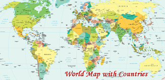
This app, "World Map With Countries," offers a user-friendly way to grasp global geography and political boundaries. It provides a detailed visualization of continents, countries (including transcontinental ones and territories), oceans, seas, islands, and more, all overlaid with a grid of meridians and parallels for precise geographical referencing. The map clearly delineates the administrative borders of each country, highlighting the interplay between geographical features and political divisions.
Key App Features:
- Visual Clarity: The app's graphical representation simplifies understanding of global boundaries and key locations.
- Comprehensive Coverage: It includes all continents, countries, and significant territories, from vast nations to smaller islands.
- Geographic Coordinates: Meridians and parallels are displayed, illustrating the geographic coordinate system.
- Political Boundaries: Accurate depictions of administrative boundaries provide a clear picture of political divisions.
- Educational Resource: Detailed information on 197 countries, including their borders and adjacent water bodies, makes this a valuable learning tool.
- Intuitive Design: The app boasts a clean, attractive interface designed for ease of use and maximum user engagement.
In Conclusion:
The "World Map With Countries" app is a superb resource for anyone seeking to improve their geographical and political knowledge. Its visual approach, comprehensive data, and straightforward design make it perfect for students, travelers, and anyone with an interest in global affairs. Download now to begin exploring the world's diverse geography and political landscape!


